Few driving experiences in the world match the raw, unfiltered drama of a Scottish Highlands road trip route. Narrow single-track roads cutting through ancient glens, sweeping mountain passes with near-zero traffic, and the kind of scenery that makes you pull over every ten minutes just to stare. This is proper driver’s territory, and if you plan it right, it becomes one of the most technically and visually rewarding journeys available anywhere in the British Isles.
Whether you’re piloting a capable SUV, a sports car with a decent ground clearance, or a well-sorted estate loaded with camping gear, the Highlands rewards those who come prepared. Here is how to do it properly.
Where to Start Your Scottish Highlands Road Trip Route
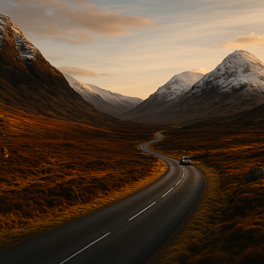
Most drivers begin in Inverness, which serves as the natural gateway to the Highlands. It’s well connected by the A9 from Perth, itself a decent stretch of dual carriageway that opens out into increasingly dramatic landscape the further north you travel. If you’re arriving from the south, the A82 along Loch Lomond and through Glencoe is arguably the better choice as a warm-up for what lies ahead. Glencoe alone, with its brooding volcanic peaks and long straight approach road, sets the tone perfectly.
From Inverness, the North Coast 500 (NC500) is the headline act. This roughly 500-mile circular route loops around the northern rim of Scotland and has rightly earned a reputation as one of Europe’s finest driving roads. It’s not just the scenery; it’s the variety of road surfaces, gradient changes, and the sheer isolation of sections like the Bealach na Bà pass near Applecross.
The Roads That Make the Scottish Highlands Road Trip Route Worth It
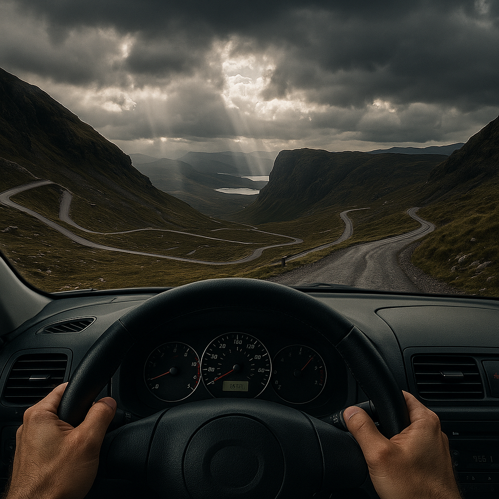
Bealach na Bà: The Technical Challenge
Bealach na Bà, translated from Gaelic as the Pass of the Cattle, is not for the nervous or the inexperienced. The ascent climbs to around 626 metres via a series of sharp, hairpin bends with gradients reaching 1-in-5 in sections. It is frequently cited alongside the Stelvio Pass and Grossglockner as one of the most technically demanding public roads in Europe. Caravan and large vehicle warnings are posted at the base for good reason. In a well-sorted car with decent tyres and working brakes, it is absolutely spectacular. Take your time, use your gears properly, and watch for oncoming vehicles on the blind crests.
The Road to Durness and Cape Wrath
The far northwest, particularly the stretch between Tongue and Durness on the A838, is where the Highlands feel genuinely remote. The road traces the Kyle of Tongue via a causeway with panoramic views across the estuary, before climbing inland through moorland that stretches to the horizon. Mobile signal drops significantly here, so download offline maps before you set off. Fuel stops are sparse; fill up in Tongue or Durness before continuing.
The A835 Gorge Road Through Torridon
Turning south from Ullapool, the roads through the Torridon mountains offer some of the finest Highland driving. The ancient Torridonian sandstone peaks rise almost vertically from the valley floor, and the narrow road demands full attention while simultaneously delivering extraordinary views. Pull-ins are marked; use them to let faster traffic pass and to take in the landscape properly.
Must-Stop Locations Along the Route
Beyond the roads themselves, the Highlands are dense with destinations worth building stops around. Eilean Donan Castle near Dornie sits at the confluence of three sea lochs and is one of the most photographed structures in Scotland. Access involves crossing a short stone bridge; parking is available but can fill quickly in peak months. Plan an early morning visit for clear light and fewer people.
Smoo Cave near Durness is a geological curiosity worth the short walk from the road. The cave system, formed partly by marine erosion and partly by freshwater, opens into a dramatic chamber with a waterfall at its rear. It takes perhaps 30 minutes to explore and provides a good leg-stretch between long driving sections.
For fuel and recovery stops, Ullapool is the most substantial town on the western leg. It has proper shops, a good selection of places to eat, and a ferry terminal connecting to the Outer Hebrides if you want to extend the trip further. The harbour is well worth a slow walk in the evening light.
Practical Vehicle and Route Planning Advice
Planning a Scottish Highlands road trip route demands more vehicle preparation than a typical motorway run. Tyre condition is critical; the road surfaces range from smooth tarmac to roughly patched single-track with loose gravel edges. Check pressures before you leave and carry a tyre repair kit at minimum. A portable compressor is worth its weight.
Fuel range management is genuinely important. Some sections of the NC500 have gaps of 40 to 50 miles between filling stations. If your car is averaging 35 mpg and has a 50-litre tank, that is comfortable; if you’re in something thirstier, top up at every opportunity. Apps like Fuelmapper or a quick Google search for the next open petrol station before you leave each town will save headaches.
Accommodation books out quickly, particularly in summer. The stretch from Ullapool to Durness has limited options; book bothies, B&Bs, or campsites well in advance. Wild camping is legal in Scotland under the Land Reform Act, but carry out all waste, use a portable fire pan if you light a fire, and park sensibly on verges to avoid causing damage.
Best Time of Year for the Scottish Highlands Road Trip Route
Late spring and early autumn represent the optimal windows. May and September offer reasonable daylight hours, lower tourist numbers than peak summer, and the kind of dramatic light conditions that make every photograph look cinematic. Summer midges, which are small biting insects, peak in June and July and are a genuine nuisance in still, humid conditions near water. A midge net, long sleeves, and Smidge repellent are standard kit for anyone camping.
Winter driving is possible but demands respect. Snow and ice on the higher passes, including Bealach na Bà, can close roads without warning. Winter tyres or all-season tyres with adequate tread are strongly recommended from November through March. The reward is extraordinary; snow-covered peaks, near-empty roads, and a stillness that is genuinely rare in modern Britain.
A Scottish Highlands road trip route is not simply a holiday drive. It is a proper test of vehicle and driver, wrapped in some of the most arresting landscape on the planet. Plan the fuel, respect the road, and take your time. Very few journeys in the UK give back as much as this one.
Frequently Asked Questions
How long does it take to drive the Scottish Highlands road trip route?
The full North Coast 500 circular route covers roughly 500 miles and can technically be driven in two to three days, but that would mean skipping most of what makes it worthwhile. Most drivers allow five to seven days to do the route justice, factoring in stops, walks, and time to explore the remote sections at a sensible pace.
Is the Scottish Highlands road trip route suitable for sports cars and low-clearance vehicles?
Many sections are perfectly suitable for sports cars, particularly on the main A-roads and the better-surfaced stretches of the NC500. However, some single-track roads and the Bealach na Bà pass have rough patches, loose gravel edges, and steep cambers that can catch out very low-slung vehicles. A car with at least 120mm ground clearance and good road tyres will manage the route without issue.
What are the fuel stop intervals along the North Coast 500?
Fuel is available in the larger towns including Inverness, Ullapool, Durness, Tongue, Wick, and Tain, but gaps between stations on the western leg can stretch to 40 to 50 miles. Always refuel when you have the opportunity rather than waiting until you’re running low. Some smaller villages have no fuel at all, so planning ahead using an offline route and fuel stop map is strongly advised.
Do I need an SUV or 4×4 to drive the Scottish Highlands?
You do not need a 4×4 or SUV for the majority of the Highland roads, which are surfaced public tarmac roads. A standard well-maintained car with good tyres is entirely adequate for the NC500 in dry conditions. However, in winter, a car with all-season or winter tyres is strongly recommended, and higher ground clearance becomes more useful on the rougher sections and if you plan to venture off the main route.
Can I drive the Scottish Highlands road trip route in a motorhome or with a caravan?
Large vehicles including motorhomes and caravans can tackle parts of the route, but the Bealach na Bà pass is explicitly signed as unsuitable for them and should be avoided. Some single-track sections are also challenging for wide or long vehicles. There are designated large-vehicle alternative routes signposted in several areas, and planning the route using a dedicated motorhome sat-nav profile is highly advisable before departing.
Leave a Reply